The AsiaPac Predicament
The South China Sea, ten years after the 2016 ruling. This is an information memo — the history, the law, the six claimants, the stakes, and the record of every attempt at a settlement. It sets out the facts and reaches no verdict of its own. A companion memo, The AsiaPac Solution, sets out one proposed way forward.
Added China’s archipelago (“Four Sha”) claim — the archipelagic-baseline definition and China’s island-group baseline argument (Section 5), and China’s corresponding response (Section 4). New text is marked in blue.
1. Six nations, one sea
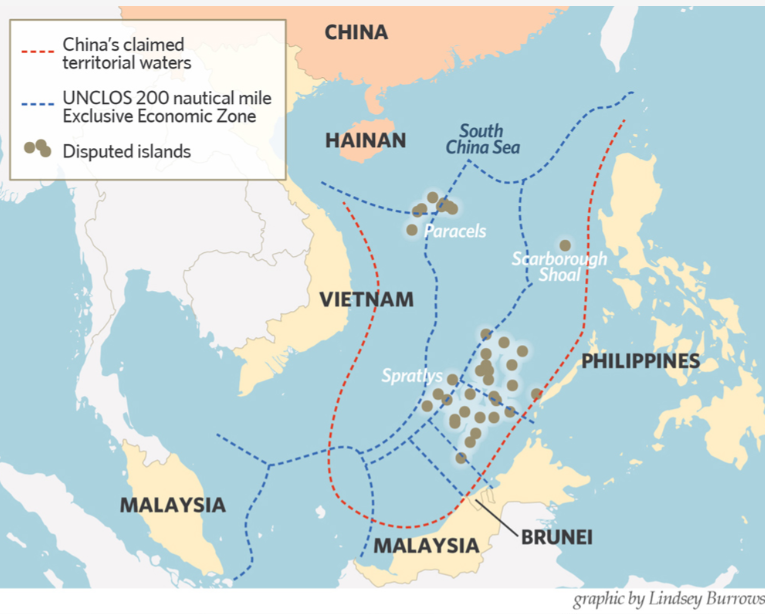
The South China Sea is claimed, in whole or in part, by six governments. Their claims overlap, contradict each other, and rest on incompatible logic — some on history, some on geography, some on discovery. All but one physically occupy features; none has an uncontested title to anything.
| Nation | Claims | On what basis | Holds now |
|---|---|---|---|
| China (PRC) | ~90% (the nine-dash line) | “Historic rights” — inherited the 1947 map, cut from 11 to 9 dashes in 1953 | 7 Spratly reefs (all now artificial islands), all the Paracels, Scarborough Shoal |
| Taiwan (ROC) | The same line — it drew the original | The 1947 eleven-dash map; still uses eleven | Itu Aba (the largest natural island), held since 1956 |
| Vietnam | All Spratlys + Paracels | History (inherited from France) + continental shelf | The most Spratly features (~21–29); lost the Paracels to China in 1974 |
| Philippines | The Kalayaan group | Proximity to Palawan + discovery (1956, 1978 decree) | ~9 features (Thitu and others); won the 2016 ruling |
| Malaysia | Southern features | Continental shelf (defined coordinates) | 5 (Swallow Reef); operates gas fields |
| Brunei | Louisa Reef | EEZ / continental shelf | Nothing — occupies no feature |
Sources — Claims and bases: each government’s official position and UN submissions (notably China’s 7 May 2009 notes verbales CML/17/2009 and CML/18/2009 to the UN Secretary-General enclosing the nine-dash-line map) and the 2016 PCA award. Occupation counts: CSIS Asia Maritime Transparency Initiative (AMTI) Island Tracker; the historical “29 features” figure for Vietnam is the older tally, ~21 the current occupied-outpost count.
Indonesia is a seventh party: not a Spratly claimant, but the nine-dash line overlaps the waters around its Natuna Islands, where its coast guard has repeatedly confronted Chinese vessels.
2. How we got here
At the end of the Second World War, not one claimant occupied a single island in the entire sea. Every occupation since has occurred as offshore oil prospects and the modern law of the sea made the features economically and strategically valuable.
- 1946–47 — The Republic of China garrisons Itu Aba and publishes the eleven-dash line map, renaming 159 features.
- 1949 / 1953 — The People’s Republic inherits the claim and trims it to the nine-dash line.
- 1951 — The Treaty of San Francisco strips Japan of the islands but names no recipient, leaving ownership legally unresolved.
- 1956 — Taiwan re-garrisons Itu Aba, permanently.
- 1970s — the Philippines and Vietnam occupy and garrison features across the Spratlys; Malaysia follows in the 1980s.
- 1974 — China takes control of the Paracels from South Vietnam after a naval clash in which dozens are killed.
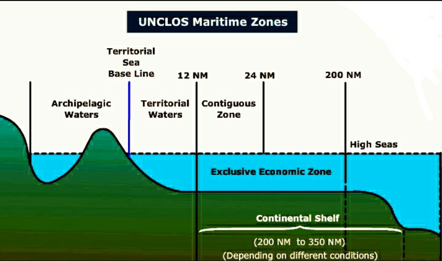
- 1982 — The UN Convention on the Law of the Sea creates the 200-mile exclusive economic zone, sharply increasing the potential value of any feature able to generate one.
- 1988 — China and Vietnam clash at Johnson Reef; dozens of Vietnamese sailors are killed and China occupies the feature.
- 1995 — China occupies Mischief Reef — its first military clash with the Philippines.
- 2002 — ASEAN and China sign the non-binding Declaration on Conduct.
- 2012 — a standoff at Scarborough Shoal; China establishes effective control.
- 2013–16 — China builds seven artificial islands (3,200 acres) with runways and radars.
- 2016 — The Hague rules the nine-dash line has no basis. China rejects it.
- 2021–25 — Vietnam conducts large-scale reclamation, reaching ~70% of China’s built area.
- 2024–26 — Rammings, water-cannon injuries, a collision, and a “nature reserve” declared at Scarborough.
3. The ruling: what was claimed, what was decided
On 12 July 2016 an arbitral tribunal in The Hague, constituted under Annex VII of UNCLOS, delivered its award in Philippines v. China. China advanced two separate claims, which the tribunal addressed separately.
What China claimed. First, historic rights to the waters themselves — the resources inside the nine-dash line, roughly nine-tenths of the sea, whatever the distance from any coast. Second, and separately, that its features are “islands” under UNCLOS, each generating its own 200-mile exclusive economic zone — so that even without the historic line, large zones would radiate from the reefs China holds.
What was decided. Both were rejected. On the first, the tribunal found that any historic rights China once held were extinguished when it ratified UNCLOS in 1996, because they cannot coexist with the EEZ system the Convention created — so the nine-dash line has no lawful effect. On the second, it examined each feature and found that not one Spratly high-tide feature is a full island under Article 121; every one is a “rock” (a 12-mile territorial sea only) or a low-tide elevation (nothing at all). With no EEZ radiating from the features, it followed that specific reefs — Mischief Reef and Second Thomas Shoal — lie inside the Philippines’ own EEZ, making China’s occupation and blockading there unlawful; the tribunal also found China had gravely harmed the reef environment. It did not decide who owns the features — sovereignty was left untouched (chapter 6).
The part that is genuinely contested. The historic-rights finding follows from China’s own ratification of UNCLOS. The island finding is more contested. Article 121 calls a feature a mere rock if it “cannot sustain human habitation or economic life of their own” — a phrase the Convention never defines. The tribunal chose a strict reading: a real island must support a stable community or an independent economy in its natural state, without outside supply. That bar sat higher than any prior case, and under a looser reading a feature with vegetation, fresh water and decades of continuous habitation — as Itu Aba has — would clear it. Taiwan argued exactly that. So the waters ruling is settled law; the islands ruling is a contested interpretive choice that a number of legal scholars consider too strict. China rejected the award in full and has since advanced a further theory — the “Four Sha,” treating four island groups as archipelagos with their own zones — which the United States and most scholars reject as well. No body can enforce any of it.
4. China’s answer
China rejects the ruling outright. Its stated position: the award is “illegal, null and void” with no binding force; China does not accept or recognise it; its sovereignty and maritime rights in the South China Sea are unaffected; and it asks whether the states backing the ruling would apply the same strict test to their own islands and reefs.
The facts around that position: China lodged a declaration under UNCLOS Article 298 in 2006 excluding disputes over sovereignty and sea boundaries from compulsory arbitration, and refused to take part in the case, arguing the tribunal lacked jurisdiction — the same Article 298 opt-out Australia lodged in 2002 (chapter 10). The tribunal was constituted under Annex VII of UNCLOS, the convention China ratified in 1996, and refused to recognise the outcome. Its strict reading of Article 121 — that even Itu Aba is a “rock” with no EEZ — would, applied evenly, also affect the 200-mile zones Japan claims from the Okinotorishima outcrop and France claims from small features across the Pacific. No body can enforce the award.
China has also advanced a positive argument of its own. It treats its South China Sea features as four island groups — the “Four Sha” — and asserts sovereignty over each as a single unit, from which it would draw straight baselines and claim the enclosed waters and the maritime zones of the group as a whole, in the manner of an archipelago. It declared such baselines around the Paracels in 1996 and has said it intends to do the same around the Spratlys. The basis for this argument, and the objections to a continental state relying on it, are set out in the next chapter.
5. What the Spratlys are — and what counts as an “island”
The Spratlys contain very little natural land. Across some 400,000 km² of sea there are only about a dozen naturally formed features larger than a hectare, under three square kilometres of dry land in total. A few have soil, vegetation and fresh water, and almost all of the vegetated features are held by states other than China:
| Feature | Natural size | Held by | What’s naturally there |
|---|---|---|---|
| Itu Aba (Taiping) | ~46 ha | Taiwan | Largest natural Spratly; the only one with fresh groundwater; shrubs, coconut, mangroves |
| Thitu (Pag-asa) | ~37 ha | Philippines | Vegetated; a permanent civilian town of a couple of hundred people |
| West York (Likas) | ~18.6 ha | Philippines | Low vegetation and scrub |
| Spratly Island | ~13 ha | Vietnam | Varied vegetation and brackish water |
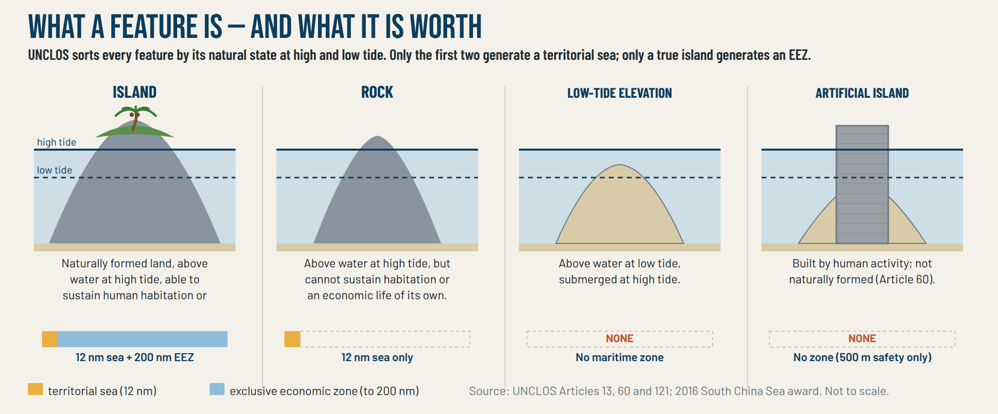
China occupies mostly bare reefs — Fiery Cross, Subi, Mischief — and has built artificial islands on them. Building land creates no legal entitlement. UNCLOS Article 121 sorts every feature into three categories: an island (naturally formed, above high tide, able to sustain human habitation or an economic life of its own) earns a 12-mile sea and a 200-mile EEZ; a rock earns only the 12-mile sea; a low-tide elevation, underwater at high tide, earns nothing. A feature is judged by its natural state — and Article 60 is explicit that artificial islands have no zone of their own. Applying that standard, the tribunal found that no Spratly feature, including Itu Aba, qualifies as a full island; each is a rock at most.
Archipelagos, and China’s “Four Sha” claim
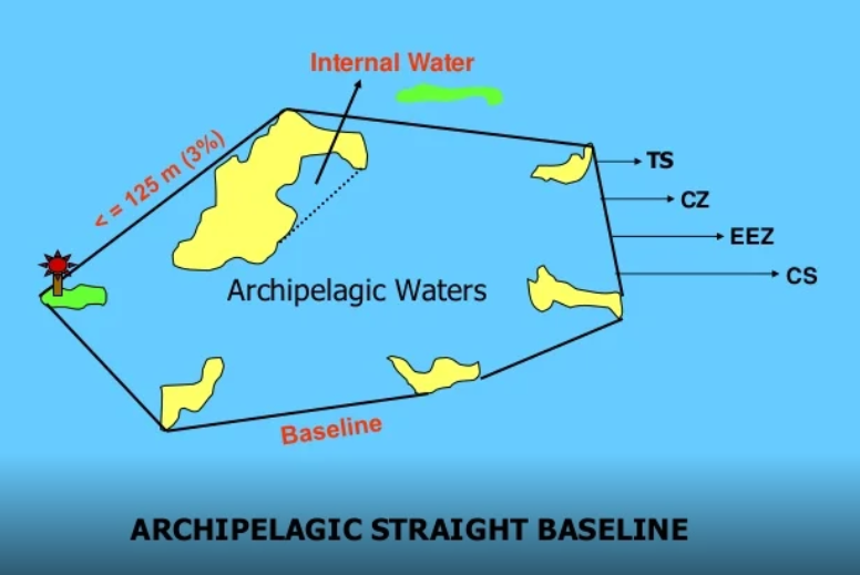
A state can also try to claim sea from islands by grouping them. Under Part IV of UNCLOS, an archipelagic State — one constituted wholly of islands, such as Indonesia or the Philippines — may draw archipelagic baselines connecting the outermost points of its outermost islands and treat the enclosed waters as sovereign “archipelagic waters.” Article 47 sets strict conditions: the ratio of water to land inside the baselines must fall between 1:1 and 9:1, and the segments must generally be no longer than 100 nautical miles. This right belongs only to archipelagic States; a continental state with offshore island groups is not one.
Since the 2016 ruling, China has advanced what is commonly termed the “Four Sha” argument. It groups its South China Sea claims into four “island groups” — Dongsha (the Pratas), Xisha (the Paracels), Zhongsha (Macclesfield Bank and Scarborough Shoal) and Nansha (the Spratlys) — and asserts sovereignty over each as a single unit, from which it would draw straight baselines and claim the enclosed waters, together with a territorial sea, EEZ and continental shelf for the group as a whole. China declared such baselines around the Paracels in 1996 and has indicated it intends to do the same around the Spratlys.
The argument is contested. Because China is a continental state rather than an archipelagic State, the United States (in its 2022 Limits in the Seas study) and most analysts hold that it cannot use Part IV archipelagic baselines, and that no rule of customary international law permits a continental state to enclose an offshore island group in this way. Even if it could, the Spratly features are so widely separated that the water-to-land ratio would greatly exceed the 9:1 limit. The Philippines and Vietnam have objected, and the 2016 tribunal declined to treat the Spratlys as a single unit, holding that each feature must be assessed individually. The status of the group claim therefore remains unsettled.
6. Two questions, not one
The dispute involves two separate questions, which are frequently conflated. Question one — what is a feature worth? That is maritime entitlement, and the 2016 ruling answered it: none of the features is a full island, so none generates a 200-mile EEZ, and the nine-dash line collapses. Question two — who owns the feature? That is territorial sovereignty, and UNCLOS does not touch it; the tribunal expressly declined to decide it. So ownership of the rocks — contested by all six claimants — remains legally unresolved. The ruling addressed the waters that can be claimed from the features; it did not address ownership of the features themselves.
7. The two Chinas agree
On the South China Sea, Taipei and Beijing hold essentially the same claim. The nine-dash line did not originate with the People’s Republic; it descends from a map drawn by the Republic of China in 1947. Taiwan holds Itu Aba, the largest feature, and when the 2016 tribunal downgraded it to a “rock,” Taiwan rejected the ruling too, just as Beijing did. Despite their broader rivalry, the two governments’ positions on this claim are substantially the same.
8. Why the sea matters — trade, fisheries and resources
Around US$3.36 trillion of trade — a third of all seaborne commerce — passes through the South China Sea each year. It holds roughly 12% of the world’s fish catch, feeding and employing at least 3.7 million people. It also contains oil and gas, though most proven reserves lie close to undisputed coastlines rather than beneath the contested features. For every claimant, the combination of shipping lanes, fisheries and seabed resources makes control of these waters both economically and strategically significant.
9. Every attempt at a deal has failed
For forty years, every serious attempt to resolve or manage the dispute has collapsed:
- The Declaration on Conduct (2002) — ASEAN and China agreed to self-restraint. Non-binding; it stopped not a single occupation or island.
- The Joint Marine Seismic Undertaking (2005–08) — the most substantial attempt: the state oil companies of the Philippines, China and Vietnam jointly agreed to survey 142,886 km² for oil. It was criticised as secretive (most of the area lay inside the Philippines’ own EEZ), tangled in corruption scandals, left to lapse, and finally declared unconstitutional by the Philippine Supreme Court in 2023.
- The 2018 China–Philippines MOU on joint oil and gas — scrapped in 2022, when Manila said talks had “got as far as it is constitutionally possible to go” without a “constitutional crisis.”
- The Code of Conduct — negotiated for more than 20 years, still with nothing binding to show.
- The 2016 ruling — the legal route to resolution; rejected by China, with no means of enforcement.
The obstacles were common to all these efforts: sovereignty was never resolved, domestic legal and political constraints limited what governments could concede, agreements reached without transparency did not survive later scrutiny, and trust between the parties remained low.
10. Australia’s position
Australia supports the ruling. It welcomed the 2016 award, calls on China to treat it as “final and binding,” and conducts freedom-of-navigation transits alongside the United States and the Philippines. Australia has itself used the same UNCLOS provision at issue in the case: in March 2002, two months before Timor-Leste’s independence, it lodged a declaration under Article 298 excluding maritime-boundary disputes from compulsory arbitration — the mechanism the Philippines later used against China — in the context of its Timor Sea boundary dispute with Timor-Leste. The Lowy Institute has noted the tension between the two positions. That dispute was later resolved through UNCLOS compulsory conciliation and a 2018 boundary treaty.
11. The predicament
The elements combine into a stand-off with no evident resolution. Six nations occupy contested features; the 2016 ruling has been rejected and cannot be enforced; China holds effective control of the features it has built and regards the sea as a core strategic interest; incidents between coast guards and fishing vessels recur; and forty years of attempted settlements have all failed. None of the parties can concede without a domestic political cost, and none can compel the others.
The principal risk is escalation through miscalculation. Confrontations around features such as Second Thomas Shoal and Scarborough Shoal — involving coast guards, maritime militia, water cannon, ramming and blocking — have intensified in recent years, and a single fatal incident could invoke the 1951 United States–Philippines Mutual Defence Treaty and draw in the United States and, through ANZUS and AUKUS, Australia.
The economic exposure is large. Bloomberg Economics estimates the first-year cost of a US–China war over the region at around US$10 trillion — close to 10% of global GDP, larger than the COVID-19 pandemic, the 2008 financial crisis and the war in Ukraine combined. About US$3.36 trillion in trade passes through these lanes each year, and semiconductor supply chains would be severely disrupted. The effects would extend beyond finance: North-East Asia imports roughly 90% of its energy, and Taiwan and Japan import some 99% of their oil, gas and coal by sea, mostly through these waters. A sustained interruption would produce fuel and food shortages within weeks across import-dependent economies, with an associated risk of civil unrest.
These are the conditions the dispute now presents: a long-standing impasse, recurring and escalating incidents, high economic stakes, and no agreed path to resolution. A companion memo, The AsiaPac Solution, examines one proposed way forward.
References & sources
- Claims, occupation and history: Britannica; Wikipedia (Spratly Islands dispute; Timeline of the South China Sea dispute; Territorial disputes in the South China Sea); Lawfare; CFR; CSIS AMTI.
- The 2016 award and Article 121 / Article 60: PCA Case No. 2013-19, Award of 12 July 2016; US-Asia Law Institute (Four Sha); Asia Times (tenth-anniversary analysis).
- Archipelagic baselines and China’s “Four Sha” / island-group claim: UNCLOS Part IV (Articles 46–47); US State Department, Limits in the Seas No. 150 (2022); CSIS Asia Maritime Transparency Initiative; The Diplomat (2023).
- Stakes (trade, fisheries and resources): Bloomberg Economics; Raymond & Welch (2022); SCMP; The Diplomat.
- Incidents and enforcement: SCMP; Al Jazeera; SeafoodSource; SAIS Review; WarWatch (2026).
- Failed deals: Philippine Supreme Court (G.R. 182734, 2023); The Diplomat; CSIS; Fulcrum (2026). Australia’s Article 298 opt-out: Lowy Institute; Oxford EJIL; Timor-Leste Government. Cost of war: Bloomberg Economics, “The $10 Trillion Fight” (2024–26). Interpretation and framing are the author’s.
Further reading & primary sources
- The full award — Permanent Court of Arbitration: The South China Sea Arbitration (Philippines v. China), PCA Case Nº 2013-19 (award and press releases, 12 July 2016).
- Interactive maps, satellite imagery and feature-by-feature detail — CSIS Asia Maritime Transparency Initiative — Island Tracker.
- The Convention itself — UN Convention on the Law of the Sea (UNCLOS), full text (see Articles 60, 74, 83, 121 and 298).
- Australia’s 2002 opt-out and the Timor resolution — Lowy Institute analysis of the PCA ruling and Timor-Leste; and the Timor-Leste Maritime Boundary Office record of the 2016–18 conciliation.
- Interactive map — Google Earth: the South China Sea features and claims (a mapped overlay of the disputed reefs and islands, with keys).
- China’s response, in its own words — Global Times (Chinese state media) on the arbitration and China’s position.
The AsiaPac Solution
A proposal for resolving the dispute — not by dividing the sea but by pooling the contested waters, anchored in UNCLOS.
Read The AsiaPac Solution →