One programme. Two steps. A modern Australia.
Every Sovereign Build Corridor carries the same integrated service stack on a single elevated structure. Freight rail at the lower deck — electrified heavy-haul replacing diesel B-doubles. Water aqueduct at the second level — the continental water transfer from the wet tropics to the Murray–Darling and beyond. Gas and fibre utilities at the third level — the energy and data backbone. Passenger maglev at the top deck — 600 km/h linking the cities. HVDC transmission on the pylon arms — the continental electricity grid carried on the same structure. One corridor, every service.
- →Every Australian city linked — capital and regional, on one integrated ground-transport network.
- →Every major deep-water port linked — Fremantle, Adelaide, Port Kembla, Newcastle, Brisbane, Gladstone, Townsville, Darwin, Port Hedland and the rest on a single electrified freight network.
- →Electricity grids linked — every state grid integrated into one continental power network via HVDC carried on the corridor.
- →Gas grids linked — northern strategic reserves connected to southern manufacturing and households, ending the export-LNG arbitrage that has left Australians paying global prices for Australian gas.
- →Water moved from the wet tropics — piped south and inland to the Murray–Darling, the central engine at Alice Hub, and the agrivoltaic Solar & Farming Zones.
- →Data backbone linked — continental fibre-optic network on the corridor, with subsea interconnectors to the Asia-Pacific community of nations.
Prove it on the east coast.
~2,400 kmPhase 0 is the Melbourne–Brisbane inland spine — a solution to the east-coast passenger, freight, and transmission problem. Built on existing road and rail corridor air-rights through Victoria, NSW, and Queensland. Approximately 2,400 km of elevated, electrified, flood-proof corridor carrying passenger maglev, electric freight, and HVDC transmission on one structure. Seven east-coast spurs connect every major port and industrial centre. Phase 0 is sized so a single Australian government can commit to it in a single term, and it delivers transformational value to the eastern third of Australia — where two-thirds of the country lives — on its own merits. The continental services (water, AI compute, gas, fibre, manufacturing at continental scale) come with Phase 1, 2, and 3.
- The east-coast freight problem solved. Three electrified heavy-haul tracks replacing diesel B-doubles on the Sydney–Melbourne–Brisbane corridor. Coastal towns freed of overnight diesel haul.
- The east-coast passenger problem solved. 600 km/h passenger maglev linking Newcastle, Sydney, Canberra, Melbourne, and Brisbane. An 18-station spine that puts every east-coast capital within two-and-a-half hours of every other — faster than the plane, door to door, at fares affordable to ordinary travellers.
- The east-coast HVDC backbone. High-voltage DC transmission carried on the pylon arms of the same structure — the east-coast trunk of the eventual continental grid. Built on Phase 0, then extended west and north when the continental phases deliver the central generation and the Asian export cables.
- The Hunter spur and Newcastle industrial gateway. The 111 km Newcastle–Muswellbrook spur connects the Hunter Valley industrial corridor to the spine on day one.
- Sovereign manufacturing build-out begins. Australian factories tooled to supply the 20-year continental order book begin shipping components to Phase 0 within the first two years.
- Indigenous partnership and royalty arrangements established. The framework that scales to the continental rollout is forged on Phase 0.
- The financial model proved in the market. Phase 0 generates revenue from operating day one — freight tolls, passenger fares, and HVDC transmission services — demonstrating the productised platform works at continental scale and the cost model holds. The continental-scale revenue (water, AI compute, electricity export) comes with the continental-scale services in Phase 1, 2, and 3.
Build the continental network.
~22,000 kmPhase 1, 2, and 3 build the continental network — approximately 22,000 km of Sovereign Build Corridor linking every Australian capital city, every commercial port, every major regional centre, and every Solar Region in the country. Six numbered corridors deliver continental water, sub-10c/kWh energy, the Indo-Pacific AI compute hub, electric freight, agrivoltaic farmland, new inland cities, sovereign manufacturing, and the Pilbara spaceport. This is the generational build that completes modern Australia.
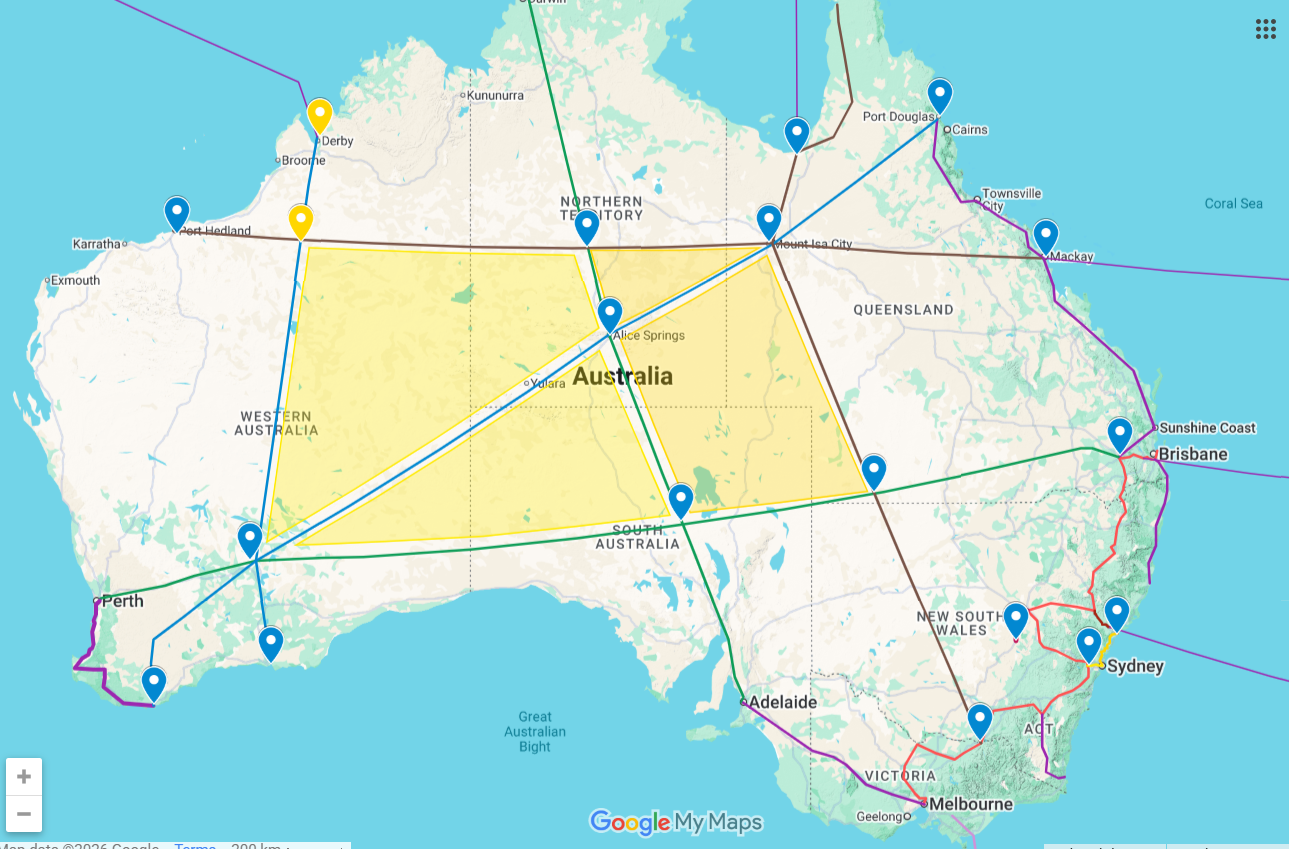
- SBC #1 — Brisbane to Perth. Approximately 3,500 km transcontinental corridor. Phase 1 priority because it connects the east-coast network to Western Australia’s resource industry and the Indian Ocean.
- SBC #2 — Darwin to Adelaide. Approximately 2,700 km via Alice Hub, the central energy and water engine. Phase 1 priority because Alice Hub anchors the entire continental water and energy network.
- SBC #3 — Gulf Coast to Adelaide. Approximately 2,500 km northern corridor connecting the northern monsoon catchment zones to the southern population centres.
- SBC #4 — Port Hedland to Mackay. Approximately 3,200 km Pilbara–Queensland resource corridor. Anchors the Pilbara spaceport and the Asia-Pacific AI compute hub.
- SBC #5 — Broome to Esperance. Approximately 1,800 km Western Australia closure corridor.
- SBC #6 — Mount Isa to Perth. Approximately 2,700 km long-haul corridor completing the continental loop.
Continental water arrives at Alice Hub from the northern monsoon catchment and gravity-feeds in every direction across the continent. Continental energy from desert solar at 1,000+ GW. Continental freight on three electrified heavy-haul tracks reaching every commercial port. Continental AI compute on inland desert campuses serving the Indo-Pacific. Continental farming on 13.4 million hectares of agrivoltaic productive country. Continental manufacturing on the 20-year industrial order book. The Pilbara sovereign space industry. New inland cities and 200 corridor towns making regional Australia genuinely habitable for the first time in a century.