The first corridor. The spine of the whole programme. Melbourne to Brisbane via Bendigo, Echuca, Shepparton, Benalla, Wangaratta, Albury, Wagga Wagga, Goulburn, Western Sydney Airport, Bathurst, Dubbo, Muswellbrook, Tamworth, Armidale, Warwick, and Toowoomba. 2,284 kilometres. Construction commencement 2027. Operational 2035.
For you
What this route does for you.
This section will describe what the route specifically delivers for the people on or near the line — journeys enabled, towns connected, what changes for everyday life. Audience-specific framing in development.
The route
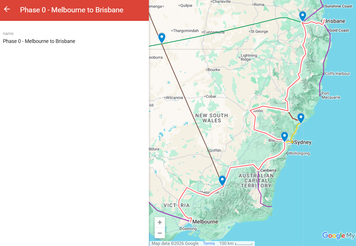
Where it goes.
Phase 0 starts in Melbourne and runs north along existing rail and transmission corridors. It crosses the Murray River at Albury, passes through Wagga Wagga and the Snowy Mountains region to Canberra, then heads east to Western Sydney Airport and up to Newcastle. From Newcastle it climbs through the Hunter Valley — Muswellbrook, Tamworth, Armidale — across the New England plateau, and through Toowoomba (via the Wellcamp Airport region) into Brisbane. About 2,284 kilometres total, almost entirely along existing corridors, with zero tunnels.
Stations on the line
Where the Phase 0 spine stops.
Eighteen maglev stations across 2,284 kilometres of inland alignment from Melbourne to Brisbane. Each station town gets a maglev passenger terminal and an electric freight terminal. Smaller communities along the corridor are served by freight sidings and connecting bus services.
Melbourne
Bendigo
Echuca
Shepparton
Benalla
Wangaratta
Albury
Wagga Wagga
Goulburn
Western Sydney Airport
Bathurst
Dubbo
Muswellbrook
Tamworth
Armidale
Warwick
Toowoomba
Brisbane
18 stations · ~135 km average between stops · realistic services with all stops add roughly 30–40 minutes to direct journey times.
Note: Newcastle is not on the Phase 0 spine. Newcastle accesses the network via Phase 0-1 (Hunter Valley spur to Muswellbrook) and connects directly to Sydney via Phase 0-2.
Direct journey times
If you board and stay on.
Journey
Distance
Maglev
Electric freight
Melbourne → Sydney
~870 km
1h 30min
3h 30min
Sydney → Brisbane
~920 km
1h 35min
3h 40min
Melbourne → Brisbane
2,284 km
3h 50min
9h 10min
Melbourne → Canberra
~660 km
1h 10min
2h 40min
Sydney → Canberra
~290 km
30min
1h 10min
Wagga Wagga → Sydney
~460 km
50min
1h 50min
Newcastle → Brisbane
~750 km
1h 20min
3h
Newcastle → Toowoomba
~620 km
1h 5min
2h 30min
Direct point-to-point times across the Phase 0 corridor. Maglev at peak speed (600 km/h sustained), electric freight at peak (around 250 km/h sustained on the dedicated multimodal viaduct). No intermediate stops. Real services stop at major stations along the way; that adds time per stop.
Distances between intermediate cities are estimates against the Phase 0 inland alignment and may shift slightly as detailed engineering matures. The 2,284 km Melbourne–Brisbane figure is locked.
Communities on the line
Towns and stations along the corridor.
Major stations: Melbourne, Bendigo, Echuca, Shepparton, Benalla, Wangaratta, Albury, Wagga Wagga, Goulburn, Western Sydney Airport, Bathurst, Dubbo, Muswellbrook, Tamworth, Armidale, Warwick, Toowoomba, Brisbane. Each station town gets a maglev passenger terminal and an electric freight terminal. Smaller stations and freight sidings serve the regional centres and farm communities along the corridor. Newcastle is not on the spine; it connects via Phase 0-1 (Hunter spur to Muswellbrook) and Phase 0-2 (direct to Sydney).
What it carries
Services on the corridor.
The full ten-service stack on the upper deck: maglev passenger, three electric freight tracks, HVDC transmission, gas, water, fibre, and integrated services. Phase 0 is built to the full multimodal viaduct specification.
When it gets built
Timing.
Phase 0 construction commences in 2027. The freight viaduct is built first and starts running in approximately Year 3 — generating revenue that funds the rest of the corridor. The full Phase 0 corridor is operational by 2035.
Design and engineering
How this route gets built.
Design and engineering detail — pylon configuration, viaduct type, terrain treatment, construction methodology, manufacturing approach. To be developed alongside the dedicated MMC engineering memo for this route.
Phase 0 engineering diagram — image to be added
Costs and funding
What this route costs.
Cost build-up and funding plan — capital, operating, lifecycle. Detailed cost engineering memo in preparation. Numbers will be published once the analysis is complete and reviewed.
Engineering memo
Read the technical study.
A dedicated engineering memo studying this route — alignment analysis, terrain data, traffic projections, cost build-up — is being developed for publication on the Multi-Modal Corridors site. Link will be added when the memo is complete.
One programme. The whole nation, built together.
Read the full plan, see the benefits, and find out how to take action.